
The Struggle to Build a Harbor*
The first time Franklin Riley, the European founder of Morro Bay, looked at the estuary, he may have thought he’d found the perfect harbor. What a stroke of luck that he could put a claim on this piece of land that was available because the two nearest Mexican era Ranchos did not contain it. It’s easy to imagine that an entrepreneurial man like Riley would think of using the semi-sheltered bay as a shipping port for travelers and cargo.
Like many to follow, Riley would be disappointed in the harbor. The estuary was connected to the Pacific Ocean through two channels, one on the north and one on the south side of Morro Rock. The strong northwesterly winds and tides made boat passage into the shallow bay through either channel challenging and sometimes very dangerous.

image credit: 1897 Topographical Map, USCG
Making a harbor out of the raw materials provided by the estuary was a mammoth task. The resources to sculpt a reliably usable harbor there would require far greater resources than the little community could provide on its own. It needed help.
It took over 60 years to achieve Riley’s dream of an active harbor for Morro Bay.
Early Attempts to Build a Harbor in Morro Bay
Much of coastal California was remote from the big transportation centers of San Francisco and southern California. Paula Carr describes how California’s sheer size and rugged geography made coastal shipping the preferred option for trade among the peripheral communities—like Morro Bay—and the bigger cities, and the broader world as well.
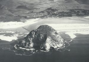
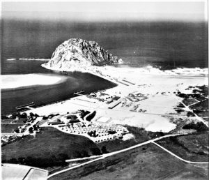
image of Morro Bay, c. 1912, credit Historical Society of Morro Bay
Everyone recognized how valuable a safe harbor in Morro Bay could be. Once inside the estuary (the bay), boats were relatively sheltered from bad weather by the natural breakwaters of the rock and sand spit. Morro Bay was (and is) remote, but the bay’s location offered potential access to seaports up and down the coast, avoiding the rugged inland routes. There were short local rail lines, but the Southern Pacific connecting to Los Angeles did not reach San Luis Obispo until 1894.
Using the bay as a commercial link to the big cities was very appealing to local agricultural producers. Early development included small wharves where cargoes of local dairy and crops could be shipped to commercial centers.
Unfortunately, it was hard to get in and out of the estuary safely. The harbor at Morro Bay was very tricky given the winds, tides and currents around the Rock. The local channels could shift frequently, so boats were often brought into the harbor by a local pilot. The dangers of the unimproved harbor are shown in the fact that one of Morro Bay’s pioneering European settlers, Rev. A.B. Spooner, lost his life trying to pilot the coastal steamer Mary Taylor into the harbor on February 5, 1877. Spooner was signaled for help and started rowing out in stormy weather to help the steamer, but he never made it. His body was not found.
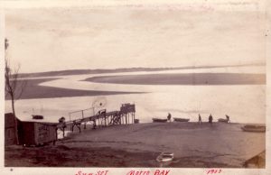
image of wharf 1917, credit: Historical Society of Morro Bay
Nevertheless, there were efforts to build wharves in Morro Bay to compete with the other coastal communities. Franklin Riley and his partners were among those who build small wharves into the estuary hoping to capture some of the coastal commerce. These facilities suffered in comparison with wharves in places like Cayucos and Port Harford.
Competition from Port Harford, Cayucos and San Simeon
Morro Bay was not the only place on the Central Coast where a boat could tie up to load or unload. Competition for this trade came from Port Harford (later called Port San Luis at Avila Beach) about 20 miles south, the Cayucos wharf built by Captain James Cass 5 miles north on Estero Bay, and a wharf at San Simeon. All of these locations were favorably sheltered from the prevailing northwesterly winds and/or offered access to deeper water that could handle the larger boats more easily.
The early commercial trade favored access at Port Harford, Cayucos and San Simeon. The San Luis Obispo Daily Telegram headline read “First Steamer Reaches County Wharf Tomorrow” on July 12, 1912, when the steam schooner Caspar was going to dock with a cargo of lumber. Carr documents that the Cayucos wharf supported extensive trade in the 1870’s through the 1890’s. Exports included grain, diary products, animals and mercury, among other things. A major import was lumber which was needed for the growing communities along the coast. It is worth noting that Carr does not refer to Morro Bay among these commercial ports.
Morro Bay residents sought Federal funding to improve the harbor during the First World War, but were rebuffed. The San Luis Obispo Tribune stated that “Morro Bay Will Not Be Improved”, saying that the Board of Engineers for Rivers and Harbors of the War Department "appears to deal the death-blow to the hopes of having Morro Bay improved by the government.” (October 3, 1919). The main reason given was the close proximity of Port San Luis at Avila, only 20 miles away. The more cost effective option of Port San Luis was a reason to delay development at Morro Bay more than once.
The Central Valley Connected with the Central Coast
There was a persistent reason for the continued push to develop the harbor in Morro Bay, a reason that it shared with the other ports along the coast. The Central Coast location was so convenient to the farms and ranches in the Central Valley that an efficient harbor there would have cost advantages over other routes to big markets, including those outside California. The Central Coast was the shortest distance between the Valley and the ocean.
This connection between the Central Valley and the Central Coast holds true today. Central Valley residents escape the summer heat in Morro Bay and Pismo Beach, just as they have since the 19th century. Many of these visitors have ended up moving to Morro Bay, often in retirement. There is a good reason that many streets in Morro Bay are named after Central Valley locations, like ‘Fresno,’ ‘Kings,’ and ‘Tulare.’
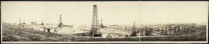
image: Mckittrick Oil Field, credit: Library of Congress
The most successful commercial linkage between the Central Valley and the Central Coast during the 20th century was the oil industry (followed by tourism). The oil fields around McKittrick, Maricopa and Coalinga were first developed in the 1870’s and 1880’s, and with the discovery of the big Kern River fields after 1899 California was for a while the biggest oil producer in the United States. The SLO Daily Telegram made the point in its article titled “Oil and a Harbor” (September 25, 1930):
“Activity of the General Petroleum corporation for a pipe line from Kettleman Hills oil field to Estero point bring [sic] forcibly to the minds of San Luis Obispo county residents the close relationship of our tidewater with the San Joaquin valley… With three oil companies moving their product to the sea through this county, the section may regain the standing it had before the big oil developments in the south, of being the greatest oil shipping center in the world.”
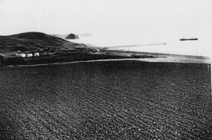
image: standard oil tanker 1936, credit: www.oldmorrobay.com
The “greatest in the world” might have been a stretch, but it is undeniably true that the oil companies saw the outlets through San Luis Obispo County as an efficient way to get their Central Valley oil to the world. However, this fact did not imply that a big harbor development was in the cards. When Standard Oil—later Chevron—built its pumping operation on Estero Bay in about 1935, the only harbor-like infrastructure it needed was a wharf with pump connections on the ocean end and some other construction at the Shore Plant (still present on the East side of Highway 1 at Toro Creek Road north of Morro Bay).
Nevertheless, the local boosters took the oil companies’ choice of the Central Coast to imply that other products of the Valley would be shipped through San Luis County. The Daily Telegram goes on:
“The big fact behind the oil company’s pipe line routing, however, is that San Luis Obispo is recognized as the real sea outlet for the products of the great inland basin of California…. All that is needed for the shipment through this county…is adequate harbor facilities on our coast.”
This boosterism misses a key point that there is an obvious difference between oil and the agricultural produce of the Valley. Shipping fruit from Visalia to L.A. or San Francisco was faster by truck from the dawn of the 20th century and from there it could be loaded on trains destined for eastern consumers. Piping oil was cost effective, and oil does not spoil: it can be shipped by sea to anyplace with time not an object.
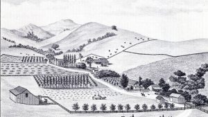
image: dairy booms in slo. Credit: San Luis Obispo Tribune
Extensive dairy operations along the Central Coast might have benefited by better harbor facilities. Dairy was a dominant industry in San Luis Obispo County in the first part of the 20th century leading up to World War II, built upon the skills of the Swiss Italian and Portuguese immigrants who arrived here in the late 19th century and early 20th century. The lack of abundant commercial carriers made the industry tilt toward less perishable products like butter, which could be shipped safely to the big cities. But dairy by itself could not support the construction of a harbor in Morro Bay, especially when alternatives like Cayucos wharf existed.
Deep Pockets Needed: The Federal Government Steps In
The local capacity to finance harbor development began and ended with wharves. These pathways on pilings could extend quite a way into the ocean, where the water was deep enough to accommodate some commercial vessels. Wharves were enough to sustain low level economic activity, and as luck would have it, they have proved valuable assets to a tourist industry, too.
Wharves did not accommodate highly intensive economic activity or high levels of development. Local boosters continued to believe that a fully developed local harbor could compare favorably with places like San Diego. The idea of a deep water port on the Central Coast continued to focus the efforts of developers and promoters who wanted to make San Luis Obispo grow.
In 1933, at the urging of local politicians, business people and agricultural producers, the Army Corps of Engineers (USACE) surveyed the Morro Bay harbor to test the feasibility of constructing a breakwater across the north channel, using Federal National Recovery Act money. This public work improvement project was explicitly promoted as making a connection to the commerce of the Central Valley, specifically Fresno and Bakersfield. A 1400 foot breakwater on the Morro Bay harbor was included in a proposal to the state Chamber of Commerce (“Site Studied by Federal Engineers,” Daily Telegram, June 14, 1933).
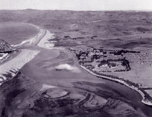
image: Morro Bay c. 1934. credit: Historical Society of Morro Bay
This depression-era appeal happened at a time when the Federal government was injecting capital into thousands of projects to create employment and economic demand. The appeals from local residents eventually pried free enough Public Works Administration (PWA) money to begin building a north breakwater stretching from the base of Morro Rock east to the bluff to close off the north channel, a total of 1,500 feet including the anchoring into the dunes. The Sun reports on April 5, 1935 that “…the north channel of the bay will soon be spanned and the entire flow of tides forever checked from carrying sand into the inner bay.”
If only it were so easy. The Federal funding that made the breakwater project possible was more precarious than many people thought. From April 1935 a series of articles in the Sun reported the stops and starts on the construction of the breakwater:
May 24, 1935: The Sun reports that the state Chamber of Commerce endorses the breakwater and will ask the Park Commission to see Federal funds.
August 23, 1935: The Sun says “Work Halted on Morro Bay Breakwater” at the order of the state PWA director.
October 4, 1935: San Luis Obispo County Supervisor Alfred L. Ferrini says Morro Bay should receive Works Progress Administration (WPA) funds in about two weeks (Sun).
December 13, 1935: The northern breakwater work creates a big beach area that allows motorists to drive to the Rock at low tide (Sun).
January 24, 1936: The construction is not quite complete, but for the first time the entire tidal flow is directed through the south channel (Sun).
February 14, 1936: The Sun declares the “Breakwater Project is Complete” with a 1,700 foot dike from the Rock to Shore, thanks to WPA funds.
February 21, 1936: Just one week after the celebration, the Sun reports that an unusually strong storm surge tore down the east (mainland) end of the dike creating a 50-foot wide channel on the north side. Repairs are needed.
Even with the eventual completion of the north breakwater, people knew that this single step to create a harbor would not produce the economic engine they envisioned. A group of boosters proposed a major development of the harbor, with six components:
- The completion of the breakwater from Rock to mainland as a road;
- A breakwater south of the Rock from spit to open sea to help define the harbor entrance;
- Dredging a channel in the estuary to accommodate larger boats;
- Construction of a bulkhead to create 125 acres of "new land" on the mainland side of the bay;
- The conversion of 250 acres of mud flats into an airfield and athletic fields;
- And to build a dike from White's Point (the Natural History Museum site) to the sand spit (“Major Bay Development Project,” the Sun, September 13, 1935).
The article does not mention any source of funding for this ambitious project. Luckily, none existed because the estuary would probably have been destroyed. The plan did include some components that would later help make the harbor a reality, including he breakwaters to the Rock and from the sand spit; dredging the channel; and construction of new land on the mainland side of the bay. These elements define much of the harbor today.
World War II Changed Everything
The gathering of war clouds over Europe was unmistakable by the early 1930’s. With Japan’s authoritarian government creating the Greater East Asia Co-Prosperity Sphere and its aggression against and eventual occupation of China in the Second Sino-Japanese War, it was clear that Japan was a strong threat to become a second front in the coming war. When Germany and Japan signed the 1936 Anti-Comintern Pact aimed to contain the Soviet Union, no one could have any illusions. The Japanese had become “honorary Aryans” and the Pacific could become a war zone.
As part of the government’s response to this growing threat from Japan, the U.S. Army and Navy conducted a series of planning exercises for war in the Pacific, collectively known as War Plan Orange, On the west coast, major war games explored sea battle strategy from the coast to Hawaii. Plans were made and executed to build bases where soldiers could be housed and trained for the coming war.
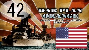
image: War Plan Orange, credit YouTube.com
In this context, it makes sense that San Luis Obispo County boosters looked to the Federal government, and specifically the military, for help in building a harbor in Morro Bay. According the Sun, in March 1936 Supervisor Ferrini took his request for help to build a harbor to the Feds. He hosted US Army Corps of Engineers Captain M. W. Gilland of the Los Angeles office to inspect the harbor and its breakwater. The article goes on to gush that “According to harbor authorities Morro Bay equals the San Diego harbor in safety and as a naval base it is said to be looked upon with favor by the government because of its proximity to the National Guard camp on the highway between Morro Bay and San Luis Obispo” (April 3, 1936).
Later In 1936, the US House of Representatives Committee on Rivers & Harbors resolved to fund engineering studies by USACE of potential harbor improvements, and Morro Bay was on the list. The Board of Supervisors responded to this by calling for a unified effort to promote the development of a seaport at Morro Bay, stating that “evidence in support of the request for harbor improvement” was so favorable that “action on the part of the Federal government is believed to be more than probable.” (Sun, July 3, 1936).
The optimism over the prospect of a harbor in Morro Bay had some foundation in the Federal reviews. But the engineers who performed the 1936 analysis did not comment specifically that the basis for developing the harbor were directed at supporting the war effort. Federal priorities at the time did not include commercial infrastructure development.
In the same time frame, the Board of Supervisors continued to look at other options. The Daily Telegram reported that “Plans of the county board of supervisors [sic] to make a survey of possible truck road routes to Port San Luis, may mark the beginning of development of a great commercial harbor and naval base for central California” (August 20, 1937). In other words, there were on-going discussions between local developers, the Federal government, and the Navy over potential sites for harbor facilities in San Luis Obispo County. Morro Bay was in the mix, but not a slam dunk candidate.
Then in 1940, the War Department submitted three plans for the development of the harbor in Morro Bay (Telegram Tribune, May 28, 1940). Local residents considered the three options and favored the one that would have cut a channel across the sandspit 3,000 feet south of Morro Rock (Telegram Tribune, June 7, 1940). The locals had gone from wanting a dike across the estuary between the mainland and the sandspit in 1935 to seeking a channel through it at about the same location in 1940. We do not have the engineering report about this option, but it would be interesting to see the analysis of how a channel at that point would affect the estuary.
In the end, nothing came of these plans and all the surrounding civic promotion in 1940. These discussions made it clear that no harbor development was going to happen unless a deep-pocketed outside actor—like the Federal government—wanted it.
The Navy Finally Commits to Morro Bay
Preparation for the coming war continued. Clearly, the Navy was aware of the options for harbor facilities on the Central Coast. In August 1941 the Navy made its move to build a harbor facility in Morro Bay: it filed a condemnation against 108 parcels in the town covering about 120 acres to build a Section Base (Telegram Tribune, August 25, 1941).
This was still before Pearl Harbor, but the perceived vulnerability of the West Coast made it important to have military surveillance. The purpose of the Section Base was to provide a harbor for coastal patrol craft. When the Navy dedicated the $2.5 million Section Base in November 1941, it was in cooperation with the U.S. Coast Guard (USCG), which would add a beach patrol station at the same site (Telegram Tribune, November 16, 1941). The base at Morro Bay was intended to keep a watchful eye on the lightly populated coast, to protect against infiltration and invasion.
During the construction of the Section Base, the Navy chose to station patrol boats at Port San Luis near Avila Beach. The threats of war made the presumably temporary stationing of these boats at Port San Luis necessary before the completion of the Morro Bay Section Base.
Over the next year, the Navy funded the construction of bulkheads intended to contain fill dredged from the estuary that would become new land. The flat new land at sea level would allow building the facilities needed to service the patrol craft intended for the base. There was room inland for administrative, training, some housing, and a station for the USCG. Breakwaters were planned for the harbor entrance, one running south from the Rock into the ocean, and a second one from the sandspit going west.
In October 1942, a trestle bridge made of locally harvested eucalyptus was completed, extending from about where Beach Street is now in a southwesterly direction to the sandspit (Telegram Tribune, October 10, 1942). The main function of the bridge was to allow the USCG to conduct beach patrols, but it was undoubtedly used in other ways as well. The trestle bridge limited access by large vessels to just the northern part of the harbor, which was where the Navy planned to have its main operations (the bridge was later modified to allow larger craft such as the Higgins landing boats to pass).
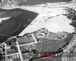
image: MB-base-aerial. Credit: WWII Archives
The remarkable photo from the WWII Archives shows the dramatic changes in the harbor compared to its natural state less than 10 years earlier. The revetments form perfectly engineered straight lines going east from Morro Rock with angled turns toward the south. The L-shaped landing pier does not yet have the companion T-pier to the south. In the lower left (southwest) corner of the photo the trestle bridge is shown before a short section of it was raised to allow passage of bigger boats into the southern part of the bay. A wide expanse of flat land near the north end of the bay has not yet been covered by military structures, let alone the 50’s-era power plant.
Taken together, these harbor improvements were remarkably similar to some of the ones local boosters sought in 1935, as noted above. Most important, the project designed by the Navy installed a permanent harbor facility for ocean-related activities at the foot of the bluff adjacent to the existing town of Morro Bay. By the end of 1943, the future of Morro Bay—whatever that might be—hinged on the harbor that had been built by the Federal government.
The Navy Can Also Change its Mind
In late April 1943, when the construction on the harbor was almost complete, the Navy sent Captain Haislip to inspect the Morro Bay Section Base. The Captain praised the base, saying “It’s a nice place [referring to Morro Bay] and it’s a fine base.” Later that same day, Captain Haislip was scheduled to review the “operating base at Avila” (Sun, April 23, 1943). Once again, Morro Bay was in a competition for a function that was only needed in one place on the Central Coast.
The Navy did an about-face just a few weeks later, when the headline in the Telegram Tribune of May 11, 1943 article was “Navy Abandons Morro Bay.” The fact that the Navy was out of appropriated funds for the Morro Bay harbor was known at this time, but the announcement made it official. The Navy curtailed funds for the Section Base because “the base was no longer useful” to them. At this point, most dredging was complete and the new land behind the revetment was in place. The breakwaters at the harbor entrance were not finished.
The patrol boats that were the original reason for building a harbor in Morro Bay were operating successfully out of Port San Luis. The Navy’s view was that the “fine base” at Morro Bay was no longer needed for the war effort unless some other agency wanted to pay for it. The Navy did not have a sentimental tie to the “fine place” that was Morro Bay, and no interest in developing the economic resource that the harbor could become. The existing facilities at the base were turned over to the USCG to continue operating beach patrols, and A. M. Mckillop, the Coast Guard station commander, asked to keep the trestle bridge in place for the duration.
It seemed in the fall of 1943 that the harbor started by the Navy would have to be completed by someone else. The Morro Bay Chamber of Commerce asked for the formation of a Morro Bay harbor district for that purpose, but Supervisor Ferrini disagreed, saying that the district should be formed on a countywide basis (Sun, October 15). Supervisor Ferrini was probably wise in this assessment because even the entire county would be stretched to fund the completion of the breakwaters and facilities.
Then everything changed again for Morro Bay, almost overnight. The war in the Pacific had become fully offensive with the ultimate goal of invading Japan. More facilities and training capabilities closer to the Asian theater were needed.
The Sun reported on November 19, 1943 that the Rivers and Harbors Committee of the U.S. House of Representatives approved the continuation of the Morro Bay project. This was followed by the Navy and USCG agreeing to the joint development of an amphibious training base (ATB), and by the President endorsing the project for funding, saying it was among the projects that “were of high importance to the Military and Naval establishments…for the prosecution of the war” (Telegram Tribune, February 11, 1944). On March 29, 1944, Congress authorized funds to build an ATB in Morro Bay.
After a long and twisting story, Federal funding was finally in place to finish building the harbor at Morro Bay.
The harbor infrastructure for the ATB was completed in short order. The T-pier was built complete with the wall to simulate the side of a troop ship. A small city of Quonset huts served the permanent military personnel, and other structures needed for the base were built. Morro Bay joined the war in an active way.
Functional Amphib Training Base some time in 1944 or 1945. Credit: Joe Dunlap.
The ATB at Morro Bay
Morro Bay was the site of one of 8 ATBs nationwide. These bases were especially important to the war in the Pacific because the strategic plan envisioned an island-by-island campaign ending with the invasion of Japan. Every battle would begin with an assault launched by troops in landing craft. These troops needed to know how to get on and off the landing craft and they needed practice to do that.
A monograph by Joe Dunlap titled “The World War II Amphibious Training Base in Morro Bay California” tells the story of the ATB through the lens of a large set of photographs. The year after the Navy and Coast Guard joined to create the base saw a war-driven rush to build the facilities needed to train young men how to use the tools of a beach landing, from troop ship to shore. Final infrastructure needed to support this work, including mundane things like a water supply and fire suppression equipment were added. Dunlap reports that at its peak, the Navy kept 175 Higgins landing craft on the bay as part of the training.
From our vantage point it’s hard to believe that the base went from a not-quite-finished harbor with an indistinct purpose in late 1943 to a fully functioning training base sometime during the late winter or early spring of 1944. During the short frantic time between when the base was fully operational until the end of the war in August 1945, about 45,000 men received training at the Morro Bay ATB. Those who went overseas took part in battles for islands that were stepping stones on the way to Japan.
From War to Peacetime
The ATB was decommissioned after the war in October 1945, and turned over to the USCG for operational control (Telegram Tribune, October 31, 1945). The Coast Guard Morro Bay Station has been in existence and working continuously since it was first created in 1942 (see the panel and story about the Guard here).
The Navy left behind over 130 acres of new and/or mostly unoccupied land on the harbor front. The flat area at the north end of the Embarcadero (where the PG&E power plant was built in the mid-1950s) was used for auto races and other kinds of outdoor recreation. Almost no businesses existed along the waterfront, and the very ownership of the tidelands south of the base was in dispute between the pre-war owners and the State of California.
The Navy retained ownership of the Embarcadero after the war but was going through a process of decommissioning and dismantling bases all over the country. In the meantime, local officials were discussing what to do with the brand new harbor they had been working so long to get.
The Telegram Tribune reported that the largest crowd ever for a Morro Bay Chamber of Commerce meeting joined Senator Chris Jesperson, State Lands Commission member Howard Jack, and Supervisor Ferrini for a meeting to discuss the formation of a harbor district. The battle lines over the private interests versus public control were drawn in comments like “Objections were voiced toward the leasing of tidelands to private interests, and it was proposed that proper steps be taken to forestall any future leases to such interests…” (February 19, 1946).
Subsequent meetings began to flesh out plans for the use of the Embarcadero, leading to a division of uses quite familiar to modern Morro Bay residents. The two biggest land uses were to be “recreation” south of 8th Street (now Marina) and “canneries” north of the trestle bridge (at Beach Street), which corresponds to the Measure D commercial fishing zone now (north of Beach Street to Coleman Drive, along the waterfront).
The County, led by Supervisor Ferrini, went before the State Lands Commission to press a claim that the state owned the tidelands on behalf of the public. Ferrini said “We feel that individuals have no right to come in and take advantage of construction work which was done by the Federal government for the benefit of all” (Telegram Tribune, February 23, 1946).
The harbor took on its current shape in 1947 when the wooden trestle bridge to the sandspit was taken down (see the story about the trestle bridge here).
The fight over public versus private ownership of the tidelands would not be finally settled until 1968 (see the story about the tidelands fight here), but the ownership of the base itself was never in doubt. The Navy declared the 120 acre parcel surplus in early 1949 and the County took title to it for the grand sum of $79,249.62. The parcel was named on the deed as “Morro Garden Farms Unit No. 2” (Telegram Tribune, August 2, 1949).
The Harbor Defines Much of Morro Bay
Morro Bay grew rapidly after the war, and the harbor was part of the reason. It was a magnet for fortune seekers and entrepreneurs of all stripes doing those most American things: going west and starting anew. One of the biggest changes was the rapid growth of the commercial fishing industry attracted to new and spacious infrastructure designed to tie ocean and land together, plus proximity to waters that had not been fished intensively before. The “fishing village” of Morro Bay lore was made in those years.
Commercial fishing saw a resurgence in the 2010s, but landings never approached the peak years in the 1950s and 1960s. Virg Moores brought sport fishing to the harbor in 1954 and this industry continues to have a significant presence on the harbor front. There was a time when Morro Bay was the largest port for landings of red abalone on the west coast. Many of the techniques and innovations in the abalone industry were perfected by Morro Bay fishermen (see the Hidden History story about abalone here).
Tourism was Morro Bay’s other signature industry, and it also grew rapidly after the war. Tourism had been a source of development in the City since the 19th century when tourists traveled from the Central Valley to the Central Coast, especially as an escape to the fresh cool air and scenery of the ocean front. The golf course and Morro Bay State Park were built in the 1920s and 1930s (much of the State Park was built with Works Progress Administration (WPA) money in the 1930s). Highways were built or improved (the famous Roosevelt Highway, aka CA Highway 1, was completed just before the war in June 1937).
Businesses supporting the fishing industry (see the story about the Boat Yard here) were established along the waterfront, but eventually the Embarcadero businesses south of Beach Street became almost exclusively geared to serve tourists. The land uses seen today along the Embarcadero are strikingly close to what San Luis Obispo County planners foresaw in 1946.
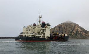
image: dredge Yaquina. credit: dredgingtoday.com
The harbor and its infrastructure enables both of these industries. Investments by the Federal government and its taxpayers through WPA and military developments made much of this infrastructure. The Federal investment continues with the periodic dredging of the harbor by the hopper dredge Yaquina, which is a familiar sight to residents.
The harbor remains the focal point of Morro Bay’s commercial life and is at the core of its identity.
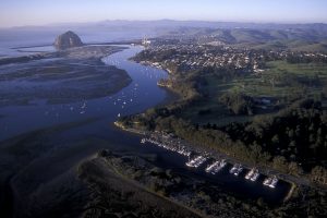
MB Harbor at Sunset - photographer - unknown
© Copyright HSMB 2025
*All rights reserved. No part of this publication may be reproduced or transmitted in any formor by any means whatsoever without express written permission from the Historical Society of Morro Bay. Contact HSMB at info@historicalmorrobay.org or via mail at P.O. Box 921, Morro Bay, CA 93443.
Preferred citation:
Silloway, Glenn. The Struggle to Build a Harbor. (Historical Society of Morro Bay, March 2021). Online at historicalmorrobay.org/hidden-history/to-build-a-harbor/